


Note: weather is an always-changing situation and developments may change at any time. As temperature and other conditions change, forecasts and predictions may need to be altered to ensure the greatest accuracy. Forecasts mentioned in this story were accurate at the time of writing.
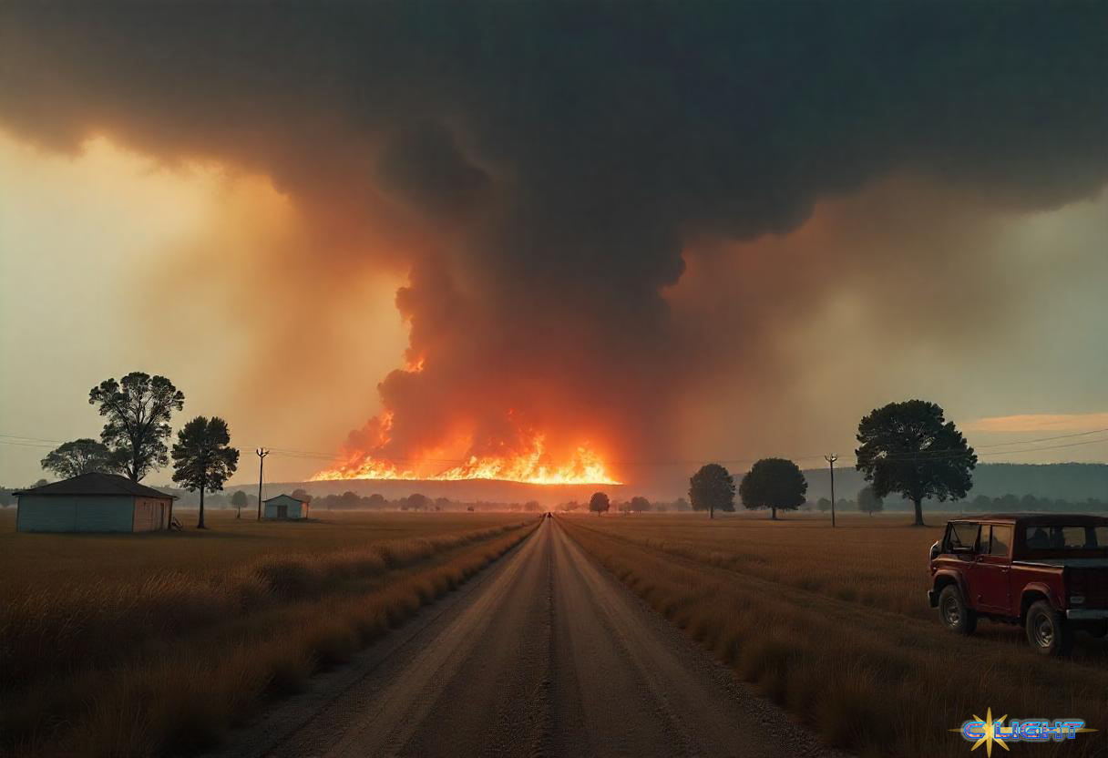
“Oklahoma, where the wind comes sweeping down the plain…” The line from the Rogers and Hammerstein musical causes the wind to sound much more fun and frivolous than the reality felt across Oklahoma and much of the MidSouth this morning. There’s no waving wheat and nothing smells sweet. In its place is acrid smoke from out-of-control wildfires that burned through the night and continue to threaten the EastCentral portion of the state.
As of this writing, there are over 300,000 people without power across Oklahoma, Arkansas, Texas, Missouri, Illinois, and Indiana. Missouri is currently the hardest hit with over 150,000 residents reportedly without power.
Multiple fatalities were reported overnight following a tornado near Poplar Bluff, MO, according to the Butler Country Sherrif.
Fires started Friday afternoon, with one near Stillwater, OK, the home of Oklahoma State University, being severe enough to warrant the cancelation of classes and postponement of athletic events. As strong winds swept across the state, fires seemed to pop up out of nowhere catching many rural areas off guard. In the town of Mannford, OK, the wind was so strong that entire trees were being engulfed by the fire within seconds.
Heavy winds across the panhandle areas of Texas and Oklahoma are being blamed for the deaths of three people near Amarillo, TX. Many truck drivers along Interstate 40 reported having to stop and park their rigs because the wind made it unsafe to travel. State Troopers in Missouri were warning travelers along Interstate 44 to be aware of the possibility of strong winds and sudden debris in the roadway as strong storms moved across the state.
What’s going on is a massive storm system sweeping across the nation. What started as heavy rains along the West Coast earlier this week transitioned to heavy snow as it crossed the Rockies and then again to heavy wind and thunderstorms as it reached the plains.
“Numerous significant tornadoes, some of which should be long-track and potentially violent, are expected on Saturday afternoon and evening,” the Federal Storm Prediction Center said in its latest forecast. Several states are already under a partial tornado watch this morning, with the intensity expected to grow as temperatures warm during the day.
The potential for unusually severe weather caused the Storm Prediction Center to issue a ‘High Risk’ warning for much of the South and Central states. The storm system is expected to continue to move Eastward during the day, arriving along the East Coast by Sunday morning. States as far North as Maryland and the District of Columbia are at risk of severe weather.
Many of the areas currently experiencing wildfires are rural communities where firefighting equipment is sparse and most firefighters are volunteers. As crews from neighboring towns pitch in to help fight the fires, winds continually whip up the possibility of sparks igniting more fires behind them or in neighboring areas. Firefighters across the states worked through the night in an attempt to put out the fires. As of 6:00 CDT this morning, more than 50 blazes were still burning across Oklahoma, several showing little containment.
The danger of powerful tornadoes and hail “as big as baseballs” still exists for today. Louisiana, Mississippi, and Alabama appear to be in the crosshairs for much of that activity.
Climate forecasters, well aware of the political situation that has seen many meteorologists and water scientists fired in recent weeks, are hesitant to blame climate change for such a severe storm. Instead, they’re using the term ‘atmospheric river,’ long and typically narrow bands of water vapor that have been getting bigger, wetter, and more frequent in the past 45 years.
Lexi Henny, an atmospheric scientist at the University of North Carolina, warns that what we’re seeing today “is still small relative to the changes that we think are going to happen” as the climate continues to warm. While no one can accurately predict weather far into the future, climate models paint a dim picture for much of the Northern Hemisphere over the next 50 years.
We will continue to monitor the situation and provide updates on social media as conditions warrant.
Discover more from Clight Morning Analysis
Subscribe to get the latest posts sent to your email.


