


In the age of 24-hour news, the narrative of a hurricane is supposed to be a familiar one. We watch the ominous swirl on the satellite, we see the wind-lashed reporters on the coast, and we track the storm’s path inland, where it inevitably weakens and fades from the headlines. But Hurricane Erik, a monster Category 4 storm churning in the Atlantic unusually early in the season, is not following that script. Its story, as it makes landfall in Mexico, is a dangerous two-act play, and while the entire country is focused on the predictable first act, it is the second act—a looming, catastrophic collision with a massive heartland heat dome—that poses the greatest and most tragically underreported threat.
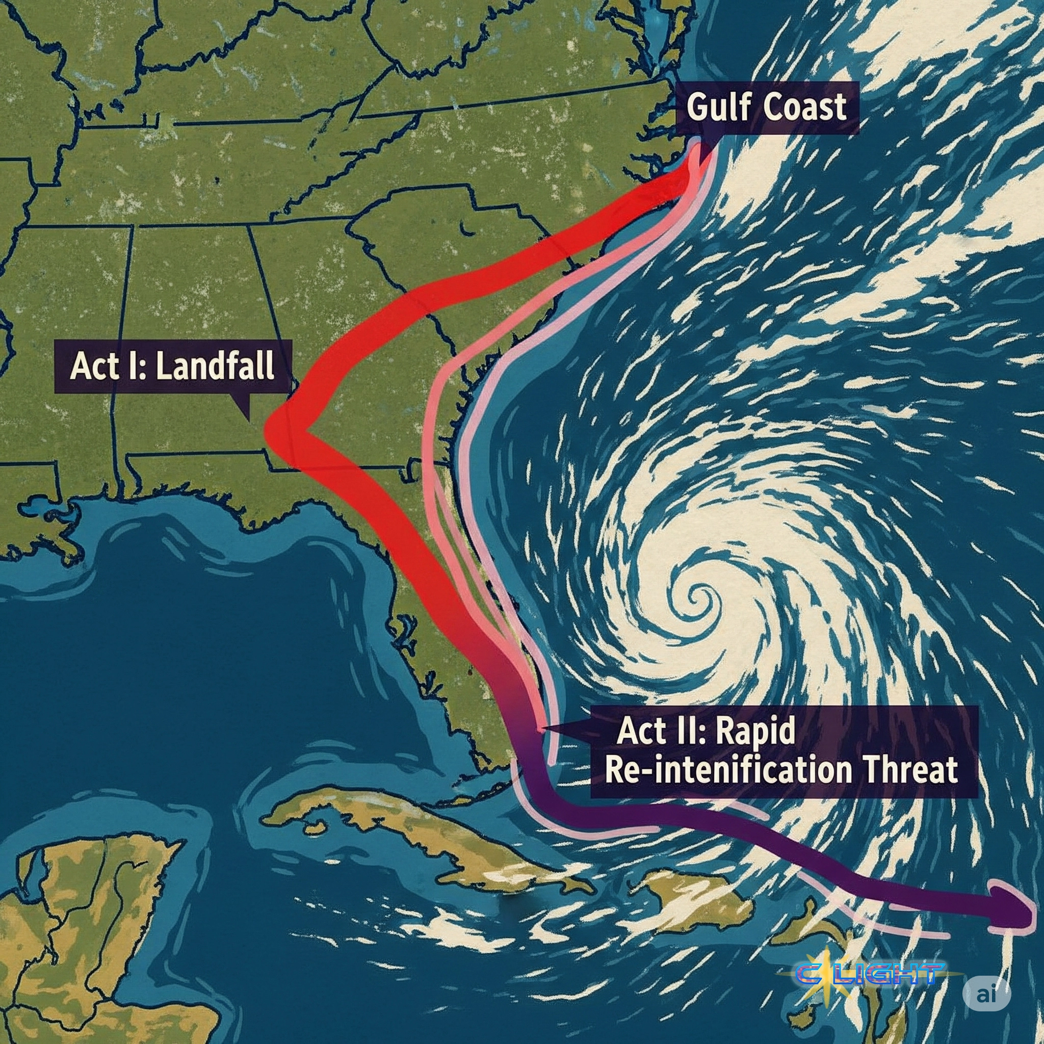
The first act is playing out as expected. Hurricane Erik, after reaching terrifying Category 4 intensity over the Atlantic, is forecast to make landfall on the Florida peninsula. As it cuts across the state, the friction of the land and the lack of warm ocean water to feed it will take its toll. The storm will weaken, likely being downgraded to a tropical storm or a low-grade hurricane by the time it exits into the Gulf of Mexico. For the national news media, this part of the story writes itself: Florida is hit hard, but the storm “loses its punch.” This is the narrative that is creating a dangerous sense of complacency.
The second act is where the real danger lies, and where, as one of my two Marine family members would undoubtedly attest, placing absolute faith in the conventional wisdom is a fool’s errand. The Gulf of Mexico is currently a cauldron. Sea surface temperatures are running several degrees above average, creating a reservoir of high-octane fuel for a cyclone. The official discussion from the National Hurricane Center (NHC) contains the words that should strike fear into anyone living on the Gulf Coast: a high potential for rapid intensification.

This means Hurricane Erik, after being left for dead by the national news, is poised for a terrifying rebirth. The weakened storm system is forecast to move back over these super-heated waters and potentially explode back into a major hurricane—Category 3 or higher—before taking aim at the northern Gulf Coast. This “zombie” storm, reborn over the Gulf, threatens a second, more powerful landfall somewhere between the Florida Panhandle and Louisiana early next week.
But the danger does not stop there. A third, even more insidious act is set to unfold for those of us here in the Midwest and further east. For weeks, a massive, stagnant high-pressure system—a “heat dome”—has been parked over the nation’s heartland, bringing oppressive heat and drought. When the remnants of a monster storm like Erik, a system still laden with immense tropical moisture, collide with the edge of this heat dome, it creates a battleground in the atmosphere.

This is not a theoretical model; it is a predictable meteorological consequence. The heat dome will act as an atmospheric wall, steering the storm’s remnants around its periphery. As the tropical moisture is forced upward over the hot, unstable air of the dome, it will be wrung out like a sponge. The result will be a series of intense, training thunderstorms capable of dumping catastrophic amounts of rain in a very short period, leading to severe and unexpected flash flooding hundreds of miles away from where the hurricane made landfall.
Furthermore, this collision of air masses is the perfect recipe for severe weather outbreaks. The sharp gradient between the hot, dry air of the dome and the moist, tropical air of the storm can generate widespread damaging winds, potentially even spawning tornadoes in places that thought they were safe from the hurricane’s wrath.
This is the true, threefold threat of Hurricane Erik: a devastating blow to Florida, a potential second catastrophic landfall on the Gulf Coast, and a subsequent outbreak of severe flooding and tornadoes across the Midwest and East. The current national narrative is dangerously incomplete, focused only on the first act of this unfolding tragedy. For those living along the storm’s full, complex path, the failure to communicate the full scope of the danger is a profound disservice. The time to prepare for the second and third acts is now, before the curtain rises on a disaster for which too many have been left tragically unaware.
Discover more from Clight Morning Analysis
Subscribe to get the latest posts sent to your email.


